|
 |
High!
On 15.12.2010 22:53, Dre wrote:
> Hey, I live in southern Tasmania!!
In Hobart?
>
> I dont suppose you could tell me where you got the data for the heightfield?
Look here: http://dds.cr.usgs.gov/srtm/version2_1/SRTM3/Australia/
These are data tiles from a Shuttle Radar Topography Mission (SRTM) in
February 2000, covering the entire land surface of the Earth between
of 3 arcseconds per data point. The name of each file indicates the
geographical coordinates of the *southwestern*, i. e. left lower corner
of the tile. So, you just look up the coordinate range of Tasmania in
your preferred atlas and find the respective tiles.
These tiles are NOT image files, but you can make them visible (and even
generate nice 3-D views, which export also to VRML) with a Windows
freeware called "3DEM". You find 3DEM here:
http://freegeographytools.com/3dem_setup.exe
With 3DEM, you can iron out error pixels (mostly resulting from cloud
cover) with the "Patch missing data" feature - but this works only for
error pixels which have no connection to the tile's edges!
To use them with PoV-Ray, you'll have to export the read-in data tile as
"ASCII terrain matrix". I wrote a POV script which generates a 16-bit
PNG heightfield from these ASCII files - attached here (ascii2png.pov)!
The ASCII files have the height data as number strings at two-digit
accuracy (xxxx.xx), each separated by a blank. PoV-Ray needs the blanks
to be replaced by commas to read the data in properly. If you have
access to Linux with its powerful UNIX console command line tools,
you're fine - just type in:
sed 's/ /,/g' original_file destination_file
and within two seconds, almost 1,5 million blanks are replaced by commas!
Unfortunately, I currently do not know of any Windows tool capable of
doing that job at a comparable speed - common GUI text editors, not to
mention full-fledged word processors toil for hours! But even if you
have no Linux on your computer, you can download a "Live CD" image of a
Debian distribution and burn it - afterwards you'll be able to boot a
proper Linux installation from the disk! If you face problems to write
data on your harddisk (because of missing rights), just try a USB stick
instead, it probably will work!
Note that the size of the data tiles is in fact 1201 by 1201 rather than
1200 x 1200, so adjacent rows and columns would repeat - if you want to
join two or more of your generated PNG heightfields, you'll first have
to remove the easternmost column and southernmost row.
And joining heightfields would be the only way to get rid of the error
pixels which, with the original tiles, lie at the edges. I also wrote a
POV script (png2ascii.pov) to re-export joined heightfields to an ASCII
terrain matrix readable by 3DEM - the software will ask you about the
size and corner coordinates and then you can smooth out the remaining
error pixels.
After exporting them back to ASCII (and, of course, once more replacing
blanks by comma) and finally to PNG, you'll have a faultless heightfield
of your desired area. Note that the creation of the PNG heightfields
required quite at lot of memory, as each "pixel" in fact is a small box
object rendered in an orthographic view without light_source but with
ambient 1 - to do 1200 x 1200 boxes, you should have at least 1.5 GB of RAM!
As the tiles are square degree tiles, the resulting cartographic
projection is cylindrical, so that only along the Equator, the
heightfields give a realistical representation of terrain, while towards
the poles, the terrain is increasingly stretched in west-east direction.
To get an undistorted landscape, you'll have to finally convert the PNG
heightfield into a mesh2 which follows Earth's curvature according to
its geographical coordinates. I also wrote a script to do this
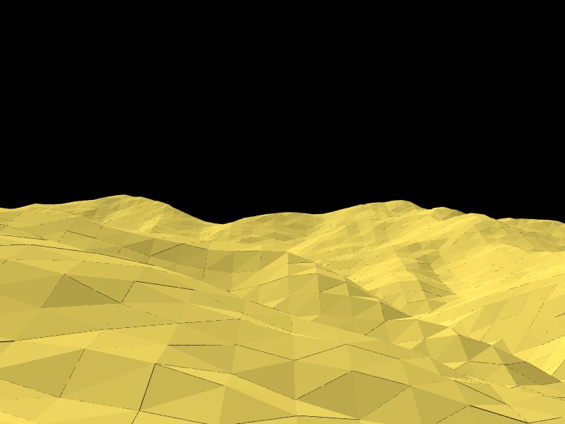
(mesh2writer), but as you see in the example rendering I attached, some
artifacts resulting from floating point inaccuracy show up. To avoid
them, we probably must use Christoph Hormann's IsoCSG include
(http://www.imagico.de/pov/ic/index.html) which is able to convert a
mesh2 into an isosurface!
I added two scripts I wrote to do the conversion from PNG to mesh2 -
mesh2writer.pov which writes the full POV code for the entire mesh (for
parsing speed reasons, the mesh2 is generated only once and then written
to harddisk), and png2mesh2.pov which includes the code written by the
former script and generates the scene from it.
> I'm very interested in recreating the area around my house for starters :)
As the SRTM data tiles mentioned above have an effective resolution of
about 90 metres per data point, you'll be better off with pixeling
heightfield from a scanned-in topographic map, perhaps 1:25,000 (which
can be quite cumbersome work)... but then adjusting it to Earth
curvature would be somewhat difficult, as those maps are based on
geodetic (equal distances between points) rather than geographic
coordinates.
> Then the whole island, that would be sweet!!!
Yes, with Tasmanian Tigers roaming the forests! In fact, I think
Tasmania a very interesting part of the world, as it is located in the
"Roaring Forties", mainly when it comes to vegetation and animals, and I
really would like to visit your island!
See you in Khyberspace!
Yadgar
Post a reply to this message
Attachments:
Download 'us-ascii' (3 KB)
Download 'png2mesh2.pov.txt' (3 KB)
Download 'ascii2png.pov.txt' (1 KB)
Download 'png2ascii.pov.txt' (1 KB)
Download '2010-11-20 afghan highlands south of koh-e baba range, take 1 (yadgar).jpg' (42 KB)
Preview of image '2010-11-20 afghan highlands south of koh-e baba range, take 1 (yadgar).jpg'
|
|